Supply Chain Network Vulnerabilities: Potential Gaps in Your Strategy
Today's supply chain professional faces a dynamic range of natural and manmade risks, including hurricanes, earthquakes, avian flu, political unrest and terrorism. Global sourcing and offshoring reduce a company's visibility and control of issues within their supply chains. Additionally, Lean supply chain valuation, just-in-time inventory and sole sourcing create networks even more susceptible to environmental risk. Although corporate risk management mitigates potential loss due to these catastrophes, penalties and insurance cannot replace market share or repair harm to a company's reputation and loss of customer confidence.
According to a 2005 FM Global/Harris Interactive research survey, 69 percent of chief financial officers, treasurers and risk managers at Global 1000 companies in North America and Europe considered property-related hazards and supply chain disruptions as major threats to top revenue sources. How can managers understand the potential of these threats to impact their business, avoid disruptions and recover as quickly as possible from disaster?
Monitoring Risks to Your Operations
Supply chain executives and business continuity managers can be inundated with volumes of data from various internal sources that need to be organized in a logical format. Corporate real estate might supply spreadsheets that contain facilities, offices and warehouse locations. Human resources departments have employee listings and home address, along with expatriates and company representatives traveling abroad. Purchasing or procurement departments have supplier and vendor data. These data form the foundation of a corporation's operational footprint.
The challenge that exists for supply chain executives is gaining the ability to rapidly determine which daily events affect a corporation's operations and need to be assessed and managed. The ability to adapt critical supply chain networks during a disaster, while ensuring minimal disruption, rests in the capacity to identify a network in a pre-crisis condition and assess various potential disruptive scenarios and their impact on a company's operations. Footprint visualization, including geographic identification of the corporate asset base, along with the origins of the supply chain, creates awareness, visibility and sensitizes decision-makers to environmental risk.
GIS for Supply Chain Risk Management
Geographical information systems (GIS) offer a valuable supply chain risk management (SCRM) tool. GIS analysis provides the opportunity to represent information visually, reducing a company's pain of preparing a response to risks or threats to its operational footprint. GIS analysis allows the user to visualize a complete company profile to include manufacturing, office and warehouse locations, as well as employee, client, customer, distributor and supplier locations. It allows for the greater understanding of the operating environment surrounding the corporate global footprint. Relationships can then be drawn between these locations, allowing for the company's supply chain to be identified and monitored.
Various types of risks — either man-made (acts of terror, corruption, crime, political instability and sabotage) and natural threats (earthquakes, floods, hurricanes, tsunamis, volcanoes) — can be mapped, layered and presented for scenarios to stress test the company's network capabilities and business continuity plans. Historical risk trends, such as earthquakes, hurricanes, volcanoes, terrorist attacks and country risk ratings can be over-layered against the network to additionally determine an operating risk environment.
GIS analysis is more than the use of mapping software or the ability to plot points on a map. It is the ability to draw relationships spatially and to identify value in each relationship. An example would be the ability to follow product through its assembly process by locating key component supplier locations and routes from the supplier to manufacturing plant, and then from the manufacturing plant to distributor and then to the customer.
Mapping Vulnerabilities
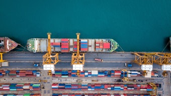
Transportation routes could include air and water ports, rail and highway systems. By plotting routes, events independent from a company's facilities can be identified and their impact assessed. Airline and water port strikes or railroad disruptions can all have a dramatic impact on a company's operations. In addition, monitoring the operating environment of the supply chain removes company's dependence on the supplier "self-reporting" disruptions.
GIS SCRM tools help identify choke points and single points of failure within a supply chain. Geographic density of key supplier locations also may encourage a company to redistribute suppliers across a geographic area. They can also facilitate the development of table-top scenarios to anticipate disruptions and identify alternative suppliers, transportation hubs and logistical routes. Historic floodplain data and earthquake activity and fault lines can quickly be used to identify areas vulnerable to specific risks.
In many companies, the emphasis has been placed on supply chain security through the use of cargo-seal security, implementation of a RFID program and the companies' participation in the U.S. Customs Trade Partnership against Terrorism Program (C-TPAT). However, if a key supplier can't make deliveries due to unexpected disruptions, a company's operations will quickly become affected. Without mapping the network, securing it against threats will be extremely difficult. Once completed though, a network map will add flexibility and resiliency by assisting in the identification of alternatives in the event of disruptions.
The immediate value geospatial analysis gives the supply chain professional is the ability for a company to visualize its supply chain by identifying locations globally. While a company may not have manufacturing facilities or offices in a particular country, that country may contain a supplier of a key component. Further value can be added by sorting and ranking suppliers based on criticality, financial contribution, loss impact valuation and just-in-time status.
The ability to identify key ports (air, shipping), rail and highways that are critical to the supply chain is vital a company's supply chain resiliency. Additionally mapping suppliers to key ports will greatly assist in the analysis of events outside a company's direct control, such as hurricanes, labor strikes, terror threats and increased security that create delays in processing cargo.
As unexpected events unfold, an analysis can quickly determine the geographic relevance of the event. Geospatial analysis takes the guesswork out of a rapid assessment; it allows supply chain executives to name specific suppliers and what their contribution is to the product cycle. By monitoring risks that develop, users can rapidly make accurate assessments of their impact. Companies can quickly reach out to potentially affected operations and suppliers and make assessments of an event's impact. An advantage can be gained over competition that may use some or all of the same supply chains. With the importing of real-time disaster data, this intelligence becomes the company's life blood. Crisis management decisions will thrive on this knowledge.
Ensuring Business Continuity
Utilizing this method will allow a company to quickly detect vulnerabilities within the network. Once a disaster occurs, the following issues will be able to be identified: 1) Which company operations are impacted, and are any customers or employees involved? 2) Which suppliers are affected, and are alternative suppliers available? 3) What key components are produced by the affected supplier, and what are the alternative supplier locations?
In one recent scenario, a flood in Mexico interrupted the movement of parts for the auto manufacturing industry. One affected company quickly reacted to the notification of the event and contacted the supplier for an immediate status update on the situation. The supplier confirmed that the typical distribution route had been wiped out. Had it remained impaired, it would have quickly amounted to more than $1 billion in losses within 90 days, but the analysis of the event, with alternative routes already having been captured, allowed stakeholders to reroute the supply chain to avoid those projected losses.
Geospatial analysis can support business continuity plans, with cells not just linked together in a spreadsheet outlining loss control activities, but mapped to geographic locations. If a company IT business continuity plan identifies outsourced network servers and their back up locations, these can be mapped. Even more critical in IT, your supply chain consists of your employees and your intellectual property, and ensuring the security of this supply chain in a crisis is of the utmost importance to any company.
Crisis management involves responding to events that impact your critical infrastructure while analyzing the details of the event to determine the root cause and geographic extent. GIS SCRM can be utilized quickly to identify additional critical infrastructure and suppliers that could be impacted. With the possibility for a large-scale outage of critical infrastructure or loss of suppliers, internally ranking your supply chain in your pre-work will allow your reaction to remain focused and prioritized.
Geospatial analysis allows users to make informed decisions that allow for immediate action grounded on having a clear understanding of their operating environment and risk landscape.
About the Author: Andrew Dailey, CPP, is the founder of GeoCritical, LLC, a risk-based critical infrastructure mapping consultancy firm. He was formerly with Electronic Data Systems in the roles of regional operational risk manager - Americas and regional security manager. Prior to joining EDS, Dailey was the manager of the General Motors Crisis Center while at Securitas Security. Holding the office of vice president and board director of the Michigan Homeland Security Consortium, he is also a Certified Protection Professional by the American Society for Industrial Security, with more than 20 years in the security industry. More information at www.georiskmap.com.
Examples of Geospatial Analysis
Illustration 1. Impact of avian flu on Asian suppliers. (Illustrative purposes only. Source: GeoCritical, LLC.)
Illustration 2. Pakistan risk assessment map. (Illustrative purposes only. Source: GeoCritical, LLC.)
Illustration 3. Impact of potential earthquake on supply network in Mexico. (Illustrative purposes only. Source: GeoCritical, LLC.)
Illustration 4. Impact of terrorist attacks on supply chain infrastructure in Mexico. (Illustrative purposes only. Source: GeoCritical, LLC.)
Illustration 5. Impact of Tropical Storm Ernesto on critical operations on the Atlantic seaboard. (Illustrative purposes only. Source: GeoCritical, LLC.)
Today's supply chain professional faces a dynamic range of natural and manmade risks, including hurricanes, earthquakes, avian flu, political unrest and terrorism. Global sourcing and offshoring reduce a company's visibility and control of issues within their supply chains. Additionally, Lean supply chain valuation, just-in-time inventory and sole sourcing create networks even more susceptible to environmental risk. Although corporate risk management mitigates potential loss due to these catastrophes, penalties and insurance cannot replace market share or repair harm to a company's reputation and loss of customer confidence.
According to a 2005 FM Global/Harris Interactive research survey, 69 percent of chief financial officers, treasurers and risk managers at Global 1000 companies in North America and Europe considered property-related hazards and supply chain disruptions as major threats to top revenue sources. How can managers understand the potential of these threats to impact their business, avoid disruptions and recover as quickly as possible from disaster?
Monitoring Risks to Your Operations
Supply chain executives and business continuity managers can be inundated with volumes of data from various internal sources that need to be organized in a logical format. Corporate real estate might supply spreadsheets that contain facilities, offices and warehouse locations. Human resources departments have employee listings and home address, along with expatriates and company representatives traveling abroad. Purchasing or procurement departments have supplier and vendor data. These data form the foundation of a corporation's operational footprint.
The challenge that exists for supply chain executives is gaining the ability to rapidly determine which daily events affect a corporation's operations and need to be assessed and managed. The ability to adapt critical supply chain networks during a disaster, while ensuring minimal disruption, rests in the capacity to identify a network in a pre-crisis condition and assess various potential disruptive scenarios and their impact on a company's operations. Footprint visualization, including geographic identification of the corporate asset base, along with the origins of the supply chain, creates awareness, visibility and sensitizes decision-makers to environmental risk.
GIS for Supply Chain Risk Management
Geographical information systems (GIS) offer a valuable supply chain risk management (SCRM) tool. GIS analysis provides the opportunity to represent information visually, reducing a company's pain of preparing a response to risks or threats to its operational footprint. GIS analysis allows the user to visualize a complete company profile to include manufacturing, office and warehouse locations, as well as employee, client, customer, distributor and supplier locations. It allows for the greater understanding of the operating environment surrounding the corporate global footprint. Relationships can then be drawn between these locations, allowing for the company's supply chain to be identified and monitored.
Various types of risks — either man-made (acts of terror, corruption, crime, political instability and sabotage) and natural threats (earthquakes, floods, hurricanes, tsunamis, volcanoes) — can be mapped, layered and presented for scenarios to stress test the company's network capabilities and business continuity plans. Historical risk trends, such as earthquakes, hurricanes, volcanoes, terrorist attacks and country risk ratings can be over-layered against the network to additionally determine an operating risk environment.
GIS analysis is more than the use of mapping software or the ability to plot points on a map. It is the ability to draw relationships spatially and to identify value in each relationship. An example would be the ability to follow product through its assembly process by locating key component supplier locations and routes from the supplier to manufacturing plant, and then from the manufacturing plant to distributor and then to the customer.
Mapping Vulnerabilities
Transportation routes could include air and water ports, rail and highway systems. By plotting routes, events independent from a company's facilities can be identified and their impact assessed. Airline and water port strikes or railroad disruptions can all have a dramatic impact on a company's operations. In addition, monitoring the operating environment of the supply chain removes company's dependence on the supplier "self-reporting" disruptions.
GIS SCRM tools help identify choke points and single points of failure within a supply chain. Geographic density of key supplier locations also may encourage a company to redistribute suppliers across a geographic area. They can also facilitate the development of table-top scenarios to anticipate disruptions and identify alternative suppliers, transportation hubs and logistical routes. Historic floodplain data and earthquake activity and fault lines can quickly be used to identify areas vulnerable to specific risks.
In many companies, the emphasis has been placed on supply chain security through the use of cargo-seal security, implementation of a RFID program and the companies' participation in the U.S. Customs Trade Partnership against Terrorism Program (C-TPAT). However, if a key supplier can't make deliveries due to unexpected disruptions, a company's operations will quickly become affected. Without mapping the network, securing it against threats will be extremely difficult. Once completed though, a network map will add flexibility and resiliency by assisting in the identification of alternatives in the event of disruptions.
The immediate value geospatial analysis gives the supply chain professional is the ability for a company to visualize its supply chain by identifying locations globally. While a company may not have manufacturing facilities or offices in a particular country, that country may contain a supplier of a key component. Further value can be added by sorting and ranking suppliers based on criticality, financial contribution, loss impact valuation and just-in-time status.
The ability to identify key ports (air, shipping), rail and highways that are critical to the supply chain is vital a company's supply chain resiliency. Additionally mapping suppliers to key ports will greatly assist in the analysis of events outside a company's direct control, such as hurricanes, labor strikes, terror threats and increased security that create delays in processing cargo.
As unexpected events unfold, an analysis can quickly determine the geographic relevance of the event. Geospatial analysis takes the guesswork out of a rapid assessment; it allows supply chain executives to name specific suppliers and what their contribution is to the product cycle. By monitoring risks that develop, users can rapidly make accurate assessments of their impact. Companies can quickly reach out to potentially affected operations and suppliers and make assessments of an event's impact. An advantage can be gained over competition that may use some or all of the same supply chains. With the importing of real-time disaster data, this intelligence becomes the company's life blood. Crisis management decisions will thrive on this knowledge.
Ensuring Business Continuity
Utilizing this method will allow a company to quickly detect vulnerabilities within the network. Once a disaster occurs, the following issues will be able to be identified: 1) Which company operations are impacted, and are any customers or employees involved? 2) Which suppliers are affected, and are alternative suppliers available? 3) What key components are produced by the affected supplier, and what are the alternative supplier locations?
In one recent scenario, a flood in Mexico interrupted the movement of parts for the auto manufacturing industry. One affected company quickly reacted to the notification of the event and contacted the supplier for an immediate status update on the situation. The supplier confirmed that the typical distribution route had been wiped out. Had it remained impaired, it would have quickly amounted to more than $1 billion in losses within 90 days, but the analysis of the event, with alternative routes already having been captured, allowed stakeholders to reroute the supply chain to avoid those projected losses.
Geospatial analysis can support business continuity plans, with cells not just linked together in a spreadsheet outlining loss control activities, but mapped to geographic locations. If a company IT business continuity plan identifies outsourced network servers and their back up locations, these can be mapped. Even more critical in IT, your supply chain consists of your employees and your intellectual property, and ensuring the security of this supply chain in a crisis is of the utmost importance to any company.
Crisis management involves responding to events that impact your critical infrastructure while analyzing the details of the event to determine the root cause and geographic extent. GIS SCRM can be utilized quickly to identify additional critical infrastructure and suppliers that could be impacted. With the possibility for a large-scale outage of critical infrastructure or loss of suppliers, internally ranking your supply chain in your pre-work will allow your reaction to remain focused and prioritized.
Geospatial analysis allows users to make informed decisions that allow for immediate action grounded on having a clear understanding of their operating environment and risk landscape.
About the Author: Andrew Dailey, CPP, is the founder of GeoCritical, LLC, a risk-based critical infrastructure mapping consultancy firm. He was formerly with Electronic Data Systems in the roles of regional operational risk manager - Americas and regional security manager. Prior to joining EDS, Dailey was the manager of the General Motors Crisis Center while at Securitas Security. Holding the office of vice president and board director of the Michigan Homeland Security Consortium, he is also a Certified Protection Professional by the American Society for Industrial Security, with more than 20 years in the security industry. More information at www.georiskmap.com.
Examples of Geospatial Analysis

Illustration 1. Impact of avian flu on Asian suppliers. (Illustrative purposes only. Source: GeoCritical, LLC.)

Illustration 2. Pakistan risk assessment map. (Illustrative purposes only. Source: GeoCritical, LLC.)

Illustration 3. Impact of potential earthquake on supply network in Mexico. (Illustrative purposes only. Source: GeoCritical, LLC.)

Illustration 4. Impact of terrorist attacks on supply chain infrastructure in Mexico. (Illustrative purposes only. Source: GeoCritical, LLC.)

Illustration 5. Impact of Tropical Storm Ernesto on critical operations on the Atlantic seaboard. (Illustrative purposes only. Source: GeoCritical, LLC.)